Sioux Falls Kayak Access Points – Big Sioux River & Skunk Creek
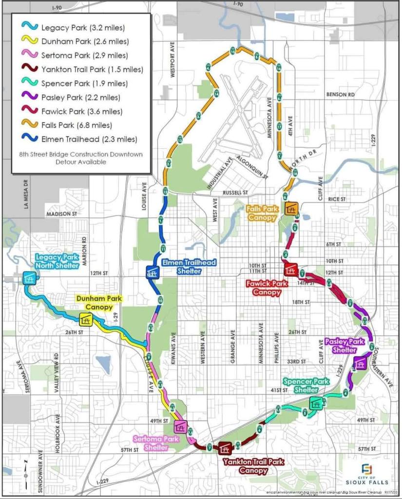
Sioux Falls Kayak Access Points – Big Sioux River & Skunk Creek
The Big Sioux River winds through the city, with access points at several major parks marked on the map. Each section shows approximate river distances between launch and take-out locations. Check that the river is at least 1.5 feet deep before launching.
River Access & Distance by Park Segment
Legacy Park to Dunham Park
Legacy Park: Near Sertoma Ave & 12th St
Dunham Park: Near Marion & W 26th St
Dunham Park to Farm Field
Dunham Park: Marion & W 26th St
Farm Field: 57th st & S Western Ave
Farm Field To Rotary Park
Farm Field: 57t st & S Western Ave
Rotary Park: E 26th St & S Southeatern Ave
Rotary Park to Fawick Park
Rotary Park: E 26th St & S Southeatern Ave
Fawick Park: Near E 10th St & S 2nd Ave (Downtown Sioux Falls)
Fawick Park to Cherapa Place
Fawick Park: E 10th St & S 2nd Ave
Cherapa Place – E 8th St By the Arc of Dreams
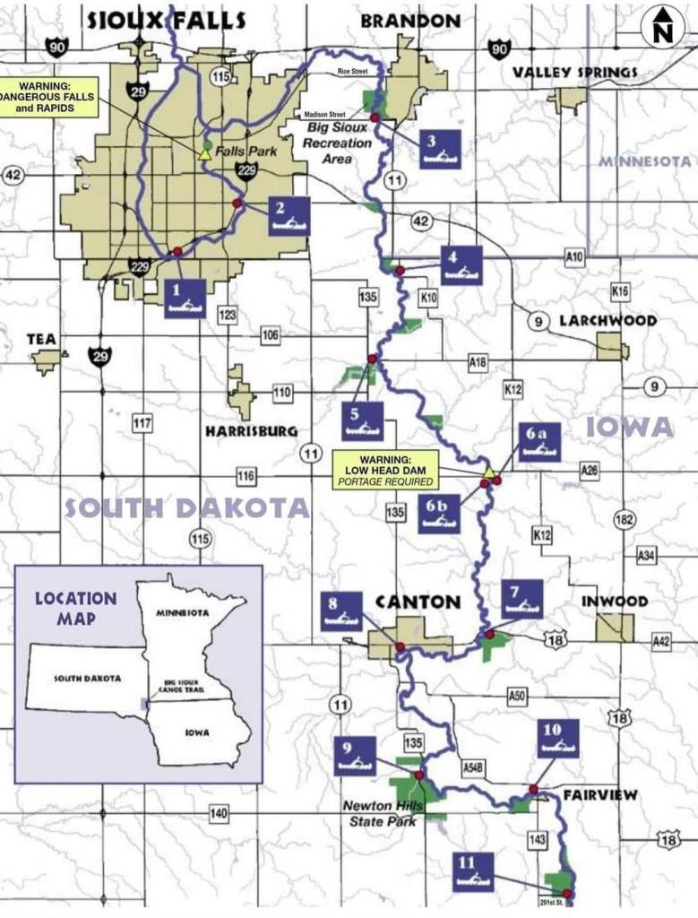
Explore the Big Sioux River Access Points
This map highlights official kayak and canoe launch sites along the Big Sioux River in South Dakota and northwest Iowa. From Sioux Falls to Fairview, find your perfect spot to hit the water. Note key safety zones and portage areas marked for your convenience!
Map includes: Big Sioux Recreation Area, Madison Street, Klondike, Newton Hills State Park, and more.
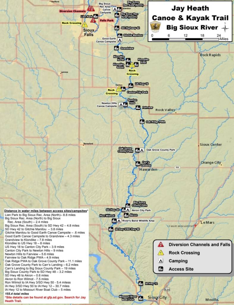
Jay Heath Canoe & Kayak Trail – Big Sioux River
This official map highlights over 150 miles of the Big Sioux River Trail, showing public kayak and canoe access points, camping areas, rock crossings, and diversion channels. Popular locations include Falls Park, Klondike, Canton, Newton Hills, and Akron. For a smooth paddling experience, the river should be at least 1.5 to 2 feet deep.
Distances between launch points are listed for planning multi-day paddles or short river floats. Ideal for paddlers exploring northwest Iowa and eastern South Dakota.
Map source: South Dakota Game, Fish and Parks — gfp.sd.gov
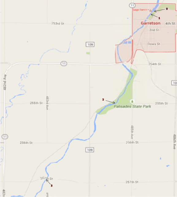
Points of Access
0. Split Rock Creek – Split Rock Park (From HWY 11 Turn East on 5th Street)(Above Dam Access to do nice leisure paddles)
Flow good most of the year since it is in the dam reservoir
1. Split Rock Creek – Split Rock Park (From HWY 11 Turn East on 5th Street)(There is a canoe and kayak ramp on the north end of the park downstream of dam)
Flow good at 4.5 feet and up SRC Flow or SRC Estimated Future Flow
2.8 miles to point 2
2. Split Rock Creek – Palisades State Park (From HWY 11 turn east on 485th Avenue and turn west on 255th Street into State Park)(Must have state park permit)
Flow good at 4.5 feet and up SRC Flow or SRC Estimated Future Flow Surfing wave forms at the parks beach over 8 feet
2.8 miles to point 3
3. Split Rock Creek – 257th Street (from HWY 11 turn east on 257th) (Ditch Entry upstream of bridge)
Flow good at 4.5 feet and up SRC Flow or SRC Estimated Future Flow
This is a fun Class I-II section of the river at the right depth, but please watch for barbwire and electric fences! Always wear a life jacket and go with a buddy. A good plus is a helmet, throw bag, and first aid kit.
Okoboji Acess Points
Canals of Wahpeton Little Spirit Center Lake Diamond Lake North
West Hottes, East Hottes and Marble Lake Hales Slough Area Upper, Lower Gar and Minnewashta
Lake/ Ponds
- Clear Lake North of Humboldt SD
- Beaver Lake Humboldt SD
- Family Park Pond Sioux Falls SD
- Grass Lake Humboldt SD
- Covell Lake Sioux Falls SD
- Island Lake Buffalo Trading Post
- Lake Alvin Harrisburg SD
- Lake Lakota Newton Hills State Park SD
- Lake Pahoja South Larchwood IA
- Lost Lake Humboldt SD
- Shoeman Park Luverne MN
- Scotts Slough Hartford SD
- Split Rock Creek Park Garretson SD
- Split Rock Creek State Park Ihlen MN
- Lake Vermillion Canistota SD
- Wall Lake West of Sioux Falls SD
- Creamery Pond Luverne MN
- Ashton Pits
- Bruce Shomaker Recreation Area
- Sandy Hollow Sioux Center IA
- Rivers Bend CampGround Rock Valley IA
Information sourced in part from SiouxEmpirePaddlers.org, a helpful guide to kayak-accessible lakes and ponds throughout the Sioux Empire region. siouxempirepaddlers.org/lakes-and-ponds/
Check River Depth Before You Paddle!
For the safest and smoothest kayaking experience, we recommend the river be at least 1.5 to 2 feet deep. You can check current water levels here: waterwatch.usgs.gov
Mother Nature’s in charge. Check the forecast before your trip!
https://www.keloland.com/weather/
Looking for a Local Paddlers Club? Check out https://siouxempirepaddlers.org/
For Paddling Convenience
Looking for inlets and outlets? Download Paddleways

Kayaking Areas
This amazing app will show you the best
kayaking areas near you by simply using
your zip!
Water Conditions
If you don’t know where to look for water
conditions, Paddleways has you covered
on that as well!
Inlet and Outlet
Paddleways will show you all of the known inlet and outlet places in your area!
App Download